Tag Archives: data source

How hot was Feb 2021?

From NOAA’s Global Climate Report – February 2021:

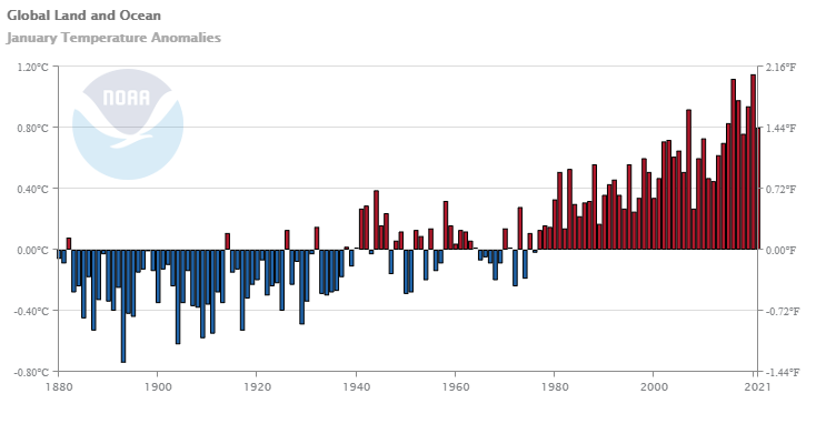
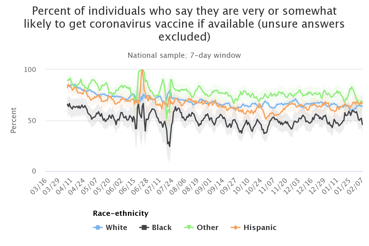
Averaged as a whole, the February 2021 global land and ocean surface temperature was 0.65°C (1.17°F) above the 20th century average—the smallest February temperature departure since 2014. However, compared to all Februaries in the 142-year record, this was the 16th warmest February on record.

Some context:

During the month, La Niña continued to be present across the tropical Pacific Ocean during February, helping dampen the global temperatures. Meanwhile, a strong negative Arctic Oscillation (AO) was also present during the first half of the month. Similar to the ENSO affecting global temperatures, the AO can influence weather patterns across the mid-latitudes. In a negative AO phase, the jet stream weakens and meanders, creating larger troughs and ridges. This allows really cold Arctic air to reach the mid-latitudes. Across the U.S., a trough over the central U.S. combined with a ridge over northern Canada to produce a Rex block, which is a blocking pattern that disrupts the jet stream and leads to more prolonged weather patterns. The AO on February 10–11 was -5.3, which essentially ties February 5, 1978 and February 13, 1969 for the lowest February value on record. They were also among the lowest 35 values for any day of the year (>99.9 percentile). By February 26, it had rebounded to +2.7 (97th percentile). The February mean AO was -1.2.

The time series data is available in the links in the additional resources box near the top of the article.

Why did wages grow in 2020?

The EPI article, Wages grew in 2020 because the bottom fell out of the low-wage labor market, by Elise Gould and Jori Kandra (2/24/2021) provides insights into changes in the labor market this past year. Key find:

Wages grew largely because more than 80% of the 9.6 million net jobs lost in 2020 were jobs held by wage earners in the bottom 25% of the wage distribution. The exit of 7.9 million low-wage workers from the workforce, coupled with the addition of 1.5 million jobs in the top half of the wage distribution, skewed average wages upward.

There are seven graphs or tables in the article with the associated data. The last two graphs are of the same type as the one copied here but for the 2000 and 2008 recessions, respectively.

How much wind power was installed in 2020?

From the eia article The United States installed more wind turbine capacity in 2020 than in any other year by Richard Bowers and Owen Comstock (3/32021):

In both 2019 and 2020, project developers in the United States installed more wind power capacity than any other generating technology. According to data recently published by the U.S. Energy Information Administration (EIA) in its Preliminary Monthly Electric Generator Inventory, annual wind turbine capacity additions in the United States set a record in 2020, totaling 14.2 gigawatts (GW) and surpassing the previous record of 13.2 GW added in 2012. After this record year for wind turbine capacity additions, total wind turbine capacity in the United States is now 118 GW.

There are two other graphs in the article and an answer to the question of which state generates the most wind power. There are also links to the data.

How should we measure COVID-19 deaths?

As we try to quantify the deaths by COVID-19 we need to measure it correctly. For example, deaths should be normalized to population size. Beyond that, we should really look at excessive mortality, that is mortality above what we might see without COVID-19. Some causes of deaths have decreased over the last year.  Our World in Data does just this on their Excess mortality during the Coronavirus pandemic (COVID-19) page. Not only do they  provide interactive graphs, such as the one copied here but also an explanation of the methodology.

A measure that is more comparable across countries is the P-score, which calculates excess mortality as the percentage difference between the number of deaths in 2020–2021 and the average number of deaths in the same period — week or month — over the years 2015–2019.

While the P-score is a useful measure, it too has limitations. For example, the five-year average death count might be a relatively crude measure of expected deaths because it does not account for trends in mortality or population size. To learn about other measures of excess mortality and their strengths and limitations, see our article with John Muellbauer and Janine Aron.

Note that the graph has times were for, say Italy, deaths were twice what would normally be expected, but at other times actually negative. As always Our World in Data provides the data and other graphics.

How hot was Jan 2021?

For NOAA’s Global Climate Report – January 2021:

The January 2021 global land and ocean surface temperature was 0.80°C (1.44°F) above the 20th century average and ranked as the seventh warmest January in the 142-year global records. January 2021 also marked the 45th consecutive January and the 433rd consecutive month with temperatures, at least nominally, above the 20th-century average.

Only 7th warmest but

The year began with a La Niña episode in the tropical Pacific Ocean that started in August 2020. The El Niño-Southern Oscillation (ENSO) can affect global temperatures. La Niña tends to cool global temperatures slightly, while El Niño tends to boost global temperatures. With a slightly cool start to the year, there is only a 2.9% chance of 2021 ending as the warmest year on record. However, there is an over 99% chance of the year ranking among the 10 warmest years on record.

and

According to NCEI’s regional analysis, North America, as a whole, had its second warmest January on record, with a temperature departure from average of +3.96°C (+7.13°F). This was only 0.10°C (0.18°F) shy of tying the record warm January set in 2006.

and

As a whole, about 5.93% of the world’s surface had a record-warm January temperature–the third highest January percentage since records began in 1951. Only Januarys of 2016 (15.73%) and 2020 (7.05%) had a higher percentage of record warm January temperatures. Meanwhile, much of northern Asia was at least 2.0°C (3.6°F) colder than average, in stark contrast to most of 2020, when the region was well above average.

As always the report is worth reading and the data in the graph is available.

What are U.S. predicted energy CO2 emissions?

The eia article EIA’s AEO2021 shows U.S. energy-related CO2 emissions rising after the mid-2030s by Perry Lindstrom and Kevin Nakolan (2/11/2021) provides the graph copied here.

EIA projects that U.S. energy-related CO2 emissions will increase in the latter years of the projection as a result of increasing economic growth that leads to growing industrial energy requirements. EIA projects energy use in transportation will increase as vehicle fuel efficiency plateaus in the mid-2020s and becomes outweighed by increases in vehicle travel demand.

There are links to data in the article.

What percent of Americans say they will get the vaccine?

The USC Center for Economic and Social Research has a page Understanding America Study with results of survey questions related to COVID-19. For example, here is a time series of the percent of individuals very or somewhat likely to get a vaccine by race (not exactly encouraging). There are numerous choices from their dropdown menu regarding perceptions, behaviors, and impacts of COVID-19. Some details about the site:

The USC Center for Economic and Social Research’s Understanding Coronavirus in America tracking survey is updated daily with the responses of members of our population-representative Understanding America Study. Each panel member is invited to respond on a pre-assigned day of the week every other week. Each data point represents a full sample of responses from the previous seven days*. The graphs are updated just after 3am PDT every day of the week.

Each graph has a link to download the data.

What contributes to sea level rise?

The Climage.gov article Climate Change: Global Sea Level by Rebecca Lindsey (1/25/2021) provides a nice overview of rising sea levels. It is easy to forget that thermal expansion of water is a significant contributor to sea level rise.

Global mean sea level has risen about 8–9 inches (21–24 centimeters) since 1880, with about a third of that coming in just the last two and a half decades. The rising water level is mostly due to a combination of meltwater from glaciers and ice sheets and thermal expansion of seawater as it warms.

To estimate how much of the observed sea level rise is due to thermal expansion, scientists measure sea surface temperature using moored and drifting buoys, satellites, and water samples collected by ships. Temperatures in the upper half of the ocean are measured by a global fleet of aquatic robots. Deeper temperatures are measured by instruments lowered from oceanographic research ships.

To estimate how much of the increase in sea level is due to actual mass transfer—the movement of water from land to ocean—scientists rely on a combination of direct measurements of melt rate and glacier elevation made during field surveys, and satellite-based measurements of tiny shifts in Earth’s gravity field. When water shifts from land to ocean, the increase in mass increases the strength of gravity over oceans by a small amount. From these gravity shifts, scientists estimate the amount of added water.

The are other graphs in the article and links to data (note the link at the end of the article).

Which 6 states together use more than half the jet fuel?

The eia article Six states accounted for more than half of U.S. jet fuel consumption in 2019 by Mickey Francis (1/27/2021) provides the graph here. Now, this isn’t surprising as CA, TX, FL, and NY are the four most populous states in that order. IL comes in 6 and GA 8. The article essentially notes this in the last line here:

In 2019, more than half of the jet fuel consumed in the United States was consumed in California, Texas, Florida, New York, Illinois, and Georgia, according to the U.S. Energy Information Administration’s (EIA) State Energy Data System. These states are home to many of the nation’s busiest airports and headquarters for many of the largest U.S. airlines. The six states are also among the most populous, accounting for about 40% of the U.S. population in 2019.

These six states represent 40% of the population but use 53% of the jet fuel and so there is a discrepancy. What accounts for the difference? For example, these 6 states account for about 44% of the GDP in the U.S. (BEA page 6), which closes the gap some. A stats project in the making. The eia page has links to their data.

Is this chart misleading?

The U.S. Bureau of Labor Statistics posts the chart (partially) copied here and last updated Sept 2020. An initial look at the graph and we see that the top 5 each have a median pay higher than the median pay in the U.S. (about $35k), but this is based on growth rate. On the other hand, if we look at the number of jobs the top 5 here are predicted to create, Table 1.3 from the BLS, we get 152.2 thousand jobs.  The sixth job on this list, home health and personal care aides, has a below median pay but is predicted to create 1,159.5 thousand jobs. There are 30 jobs listed in table 1.3 and home health and personal care aides represents about 45% of predicted new jobs created on this table. One can download the data in table 1.3 in an xlsx file.