Tag Archives: data source

Data on Sustainable Development Goals?

The World Bank has 17 sustainable development goals and a portal to information about the goals as well as an abundance of data: Atlas of Sustainable Development Goals  One path from this page is the World Development Indicators page:

The World Development Indicators is a compilation of relevant, high-quality, and internationally comparable statistics about global development and the fight against poverty. The database contains 1,600 time series indicators for 217 economies and more than 40 country groups, with data for many indicators going back more than 50 years.

One can explore data with interactive graph, query databases, or download data.

How hot was October 2020?

From the NOAA Global Climate Report – October 2020:

The October 2020 global land and ocean surface temperature was the fourth highest for October since global records began in 1880 at 0.85°C (1.53°F) above the 20th century average of 14.0°C (57.1°F). Only Octobers of 2015 (+1.03°C / +1.85°F), 2019 (+0.95°C / +1.71°F), and 2018 (+0.93°C / +1.67°F) were warmer. The ten warmest Octobers have occurred since 2005, while the seven highest October temperature departures from average have occurred in the last seven years (2014–2020). October 2020 also marks the 44th consecutive October and the 430th consecutive month with temperatures, at least nominally, above the 20th century average.

Europe was warm:

According to NCEI’s regional analysis, Europe had its warmest October on record, with a temperature departure of +2.17°C (+3.91°F). This surpassed the previous record set in 2001 by 0.06°C (0.11°F).

For the year so far:

Averaged as a whole, this was the second warmest January–October for global land and ocean, with a temperature departure at 1.0°C (1.8°F) above the 20th century average. This value is only 0.03°C (0.05°F) shy of tying the record set in January–October 2016. According to our Global Annual Temperature Rankings Outlook, the year 2020 is very likely to rank among the three warmest years on record.

The data is available in the additional resources box near the top of the page.

Where are fish going?

The Climate.gov article In search of cooler waters, marine species are shifting northward or diving deeper by John Dos Passos Coggin (4/3/2020) explains:

The graphs show the annual change in latitude and depth of 140 marine species along the northeastern U.S. coast and in the eastern Bering Sea. Changes in geographic distribution have been aggregated across all 140 species. In waters off the Northeast, fish and shellfish are moving northward at a significant rate; in the eastern Bering Sea, they are still shifting northward but at a lesser rate. Likewise, marine species in both regions are moving to deeper waters, but the rate of change in depth is especially high along the northeastern coast.

To learn more go to the GlobalChange.gov Marine Species Distribution page. On this page there is a link to oceanadapt.rutgers.edu to get data, although you will have to register.

Who earned the most in the 3rd quarter of 2020?

The U.S. Bureau of Labor Statistics has a Graphics for Economic News Releases page. The graph copied here is median usual weekly earnings of full-time wage and salary workers. Most of the patters are not a surprise, such as men earning more than women.  What may be new here is that Asian women ($1224) out earned White men ($1122). Asian men out earned all others at $1542. The page includes seven other charts with the data.

How hot was September 2020?

From the NOAA Global Climate Report – September 2020:

Averaged as a whole, the September 2020 global land and ocean surface temperature was the highest for September in the 141-year record at 0.97°C (1.75°F) above the 20th century average of 15.0°C (59.0°F). This value surpassed the previous record set in 2015 and, again in 2016, by only 0.02°C (0.04°F).

The global land-only surface temperature for September was also the highest on record at 1.47°C (2.65°F) above average. The previous record of 1.40°C (2.52°F) was set in September 2016.

Time series data is available with the link in the box above the climate anomalies map near the top.

How important is manufacturing to the U.S. economy?

At the end of August I posted about the number of manufacturing jobs in the U.S in the post How many people are employed in manufacturing? The Census Bureau has a recent post, Manufacturing Still Amon Top Five U.S. Employer by Adam Grundy (10/2/2020) that adds some context. Manufacturing is the fifth-largest employer with health care and social assistance at the top.  As the graphic here shows, manufacturing has a better than average salary. Also,

According to the Census Bureau’s Preliminary Profile of US Exporting Companies in 2017-2018, nearly six in 10 U.S. exporting dollars come from manufacturers.

There are other graphics and links to data in the article.

How does U.S. covid testing compare to other countries?

Our World in Data has an interactive graph that plots covid confirmed cases by tests both per million people and including an element of time. Copied here is one example with the U.S. and other selected countries. The paths for each country is from Jan 21 to Oct 5. So, for example, while the U.S. has increased testing (going up along the y-axis)  it has also had an increase in the confirmed cases (moving to the right along the x-axis). In the end the test positive rate has been fairly stable around 6-7%. Explore this graph by comparing other countries. As always, Our World in Data makes the data available.

What is the connection between poverty and extracurricular activities?

The Census Bureau post Even Short-Term Spells of Poverty Lower School-Aged Children’s Involvement in Extracurricular Activities by Brian Know (9/23/2020) quantifies the challenges of students  due to even temporary spells of poverty.

The percentage of children ages 6 to 11 taking lessons was significantly different between those who were in poverty some months in the year (22.5%) and those in poverty the entire year (16.2%).

Among children ages 12 to 17, involvement in lessons did not differ between children in poverty some months compared to all months in the year.

Similar to involvement in sports, taking lessons was more common in both age groups among children who did not experience any poverty compared to children who experienced poverty some months in the year.

There are links to data sources and two other graphs.

What was the 2020 Arctic sea ice minimum?

The climate.gov article 2020 Arctic sea ice minimum second lowest on record by Michon Scott (9/21/2020) reports:

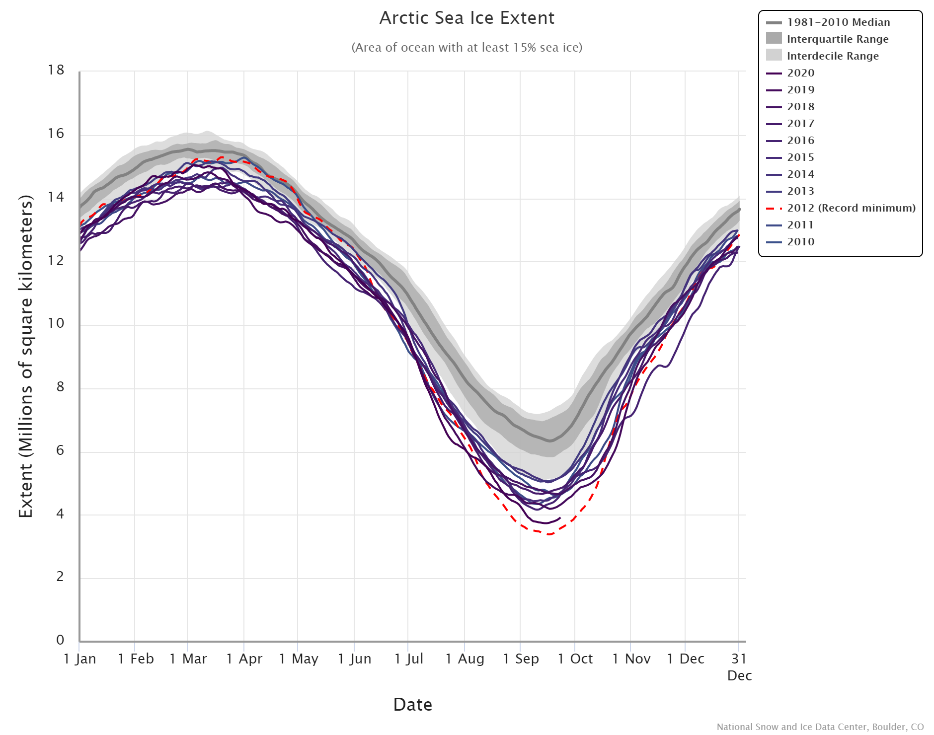
On September 15, 2020, the National Snow and Ice Data Center (NSIDC) announced, Arctic sea ice appeared to have reached its annual minimum extent. At 1.44 million square miles (3.74 million square kilometers), this minimum was second only to the record-low extent observed on September 17, 2012. The 2020 figure—preliminary because a late-season surge of summer warmth could still drop the extent further—continued an observed trend of long-term Arctic sea ice decline.

The graph here is from the National Snow and Ice Data Center’s Chartic Interactive Sea Ice Graph (a really great visual). I selected 2010-2020. The year 2012, still the current record, was an impressive minimum and this year is the first in the last 8 to come close.

From the article:

Among long-time observers of Arctic sea ice, the 2020 value was significant in that it not only punctuated a long-term decline, but also because it fell below the 4-million-kilometer (1.5-million-mile) threshold for only the second time in the satellite record—after  2012, when the minimum extent dipped to 1.31 million square miles (3.39 million square kilometers). Ted Scambos, senior research scientist at the Earth Science Observation Center at the University of Colorado-Boulder, says, “This threshold means the Arctic is more ocean than ice, a blue highway that’s been open since mid-July and won’t close until well into October, and a huge fetch for wave action along an 8,000-mile open coast of Siberia and Alaska.” The combination of sea ice decline and permafrost thaw can lead to coastal erosion as more abundant waves wear away newly softened coastlines.
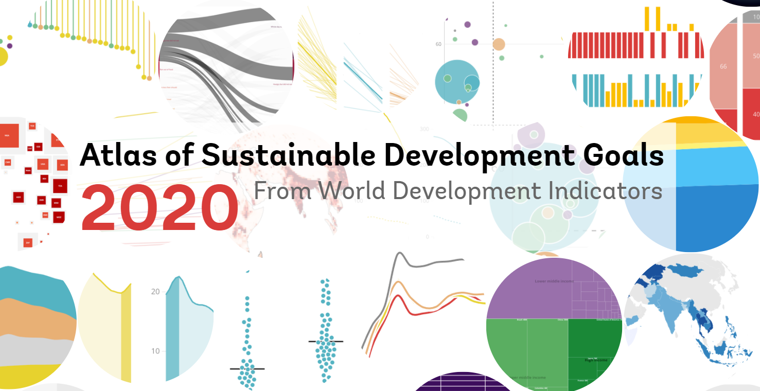
What is median household income by race and ethnicity?

The EPI article Racial disparities in income and poverty remain largely unchanged amid strong income growth in 2019 by Valerie Wilson (9/16/2020) reports the data from the Census Bureau on income and poverty in the graph copied here.

…real median household income increased 10.6% among Asian households (from $88,774 to $98,174), 8.5% among Black households (from $42,447 to $46,073), 7.1% among Hispanic households (from $52,382 to $56,113), and 5.7% among non-Hispanic white households (from $71,922 to $76,057), …

There is a second graph on poverty rates and data is included for both graphs, as well as a link to the original Census Bureau data.