The USGS post High Plains Aquifer Groundwater Levels Continue to Decline (6/16/17) summarizes the results from the USGS report Water-Level and Recoverable Water in Storage Changes, High Plains Aquifer, Predevelopment to 2015 and 2013–15.
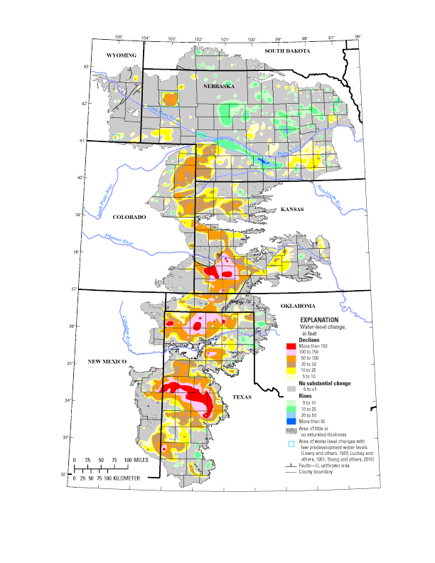
In 2015, total recoverable water in storage in the aquifer was about 2.91 billion acre-feet, which is an overall decline of about 273.2 million acre-feet, or 9 percent, since predevelopment. Average area-weighted water-level change in the aquifer was a decline of 15.8 feet from predevelopment to 2015 and a decline of 0.6 feet from 2013 to 2015.
A little geography:
The High Plains aquifer, also known as the Ogallala aquifer, underlies about 112 million acres, or 175,000 square miles, in parts of eight states, including: Colorado, Kansas, Nebraska, New Mexico, Oklahoma, South Dakota, Texas and Wyoming. The USGS, at the request of the U.S. Congress and in cooperation with numerous state, local, and federal entities, has published reports on water-level changes in the High Plains aquifer since 1988 in response to substantial water-level declines in large areas of the aquifer.
A more recent article in the Conversation, Farmers are drawing groundwater from the giant Ogallala Aquifer faster than nature replaces it by
In my view, Plains farmers cannot afford to continue pushing land and water resources beyond their limits – especially in light of climate change’s cumulative impact on the Central Plains. For example, a recent study posits that as droughts bake the land, lack of moisture in the soil actually spikes temperatures. And as the air heats up, it further desiccates the soil.
This vicious cycle will accelerate the rate of depletion. And once the Ogallala is emptied, it could take 6,000 years to recharge naturally. In the words of Brent Rogers, a director of Kansas Groundwater Management District 4, there are “too many straws in too small of a cup.”
The USGS post and the Conversation article are useful for a QL based course. The full USGS report has links to water-level data sources starting on page 7.