Tag Archives: Antarctica

What is Thwaites?

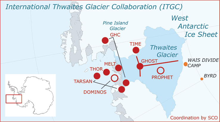
Thwaites is an important glacier. In fact, it is so important it gets in own set of webpages. From The International Thwaites Glacier Collaboration (ITGC):

The NERC and NSF partnership, called the International Thwaites Glacier Collaboration (ITGC), covers research across Thwaites Glacier and its adjacent ocean region; the glacier flows into Pine Island Bay, part of Amundsen Sea. ITGC is the largest joint UK-US project undertaken on the southern continent in 70 years.

Over the past 30 years, the amount of ice flowing out of this 120-kilometer-wide region has nearly doubled. Overall the glacier is the size of the island of Britain, or the state of Florida, and it straddles some of the deepest bedrock in the southern continent.

From a CIRES article The Threat from Thwaites: The Retreat of Antarctica’s Riskiest Glacier (12/12/2021):

“Thwaites is the widest glacier in the world,” said Ted Scambos, a senior research scientist at the Cooperative Institute for Research in Environmental Sciences (CIRES). “It’s doubled its outflow speed within the last 30 years, and the glacier in its entirety holds enough water to raise sea level by over two feet. And it could lead to even more sea-level rise, up to 10 feet, if it draws the surrounding glaciers with it.”

The CIRES article has interesting information about the dynamics at play. The ITGC pages includes some education resources and a data page with links to data in various types but one is a csv file.


A heatwave where?

From the article The 2019/2020 summer of Antarctic heatwave by Sharon A. Robinson et. e. (3/30/2020) in Global Change Biology:

Heatwaves are rarely reported in Antarctica, but elsewhere are often classified as three consecutive days with both extreme maximum and minimum temperatures. Using this classification, Casey experienced a heatwave between 23 and 26 January with minimum temperatures above zero and maximum temperatures above 7.5°C. Casey also recorded its highest maximum temperature ever (9.2°C) on 24 January followed by its highest minimum (2.5°C) the following morning.

Interestingly,

In the past, much of East Antarctica has been spared from rapid climate warming due in part to ozone depletion, which cools surface temperatures slightly and enhances the strength of the westerly wind jets which shield Antarctica from more northerly warming air (Bornman et al., 2019; Robinson & Erickson, 2015).

But,

 In late 2019, stratospheric warming led to an early breakup of the ozone hole (Lewis, 2019) and Antarctic temperature records started to break (Figure 1a). In what we believe is a first, we report a heatwave event at Casey Station, East Antarctica (Figure 1b) in January, to add to the record high temperatures reported for Antarctica in February.

Impacts,

Although it is too early for full reports, this warm summer will have impacted Antarctic biology in numerous ways, probably leading to long‐term disruptions at ecosystem, community and population scales.


How quickly is Antarctica losing ice?

Time series of cumulative anomalies in SMB (blue), ice discharge (D, red), and total mass (M, purple) with error bars in billions of tons for (A) West Antarctica, (B) East Antarctica; (C) Antarctic Peninsula), and (D) Antarctica, with mean mass loss in billions of tons per year and an acceleration in billions of tons per year per decade for the time period 1979 to 2017.


The new paper, Four decades of Antarctic Ice Sheet mass balance from 1979–2017, by Eric Rignot, et. el (PNAS 1/14/19) states

The total mass loss from Antarctica increased from 40 ± 9 Gt/y in the 11-y time period 1979–1990 to 50 ± 14 Gt/y in 1989–2000, 166 ± 18 Gt/y in 1999–2009, and 252 ± 26 Gt/y in 2009–2017, that is, by a factor 6.

An interesting fact from the paper:

Antarctica contains an ice volume that translates into a sea-level equivalent (SLE) of 57.2 m.

Note: 52.2m is about 188 feet. The graph with caption here is from the paper. The Washington Post has a summary of the paper in the article Ice loss from Antarctica has sextupled since the 1970s, new research finds by Chris Mooney and Brady Dennis (1/14/19) and notes

It takes about 360 billion tons of ice to produce one millimeter of global sea-level rise.

Based on the last two quotes, How much ice is there on Antarctica?  NASA’s Vital Signs of the Planet has Antarctica Ice data on their Ice sheets page.

Related Post: How well do we understand rising sea levels?

How fast is Antarctica melting (and a quick calculus project)?

A recent NYT article, Antarctica Is Melting Three Times as Fast as a Decade Ago by Kendra Pierre-Louis (6/13/2018), states clearly that Antarctica is melting, well, three times faster than a decade ago, which is a rate of change statement. Rapid melting should cause some concern since:

Between 60 and 90 percent of the world’s fresh water is frozen in the ice sheets of Antarctica, a continent roughly the size of the United States and Mexico combined. If all that ice melted, it would be enough to raise the world’s sea levels by roughly 200 feet.

Any calculus student can roughly check the melting statement.  Antarctica ice data is available at NASA’s Vital Signs of the Planet Ice Sheets page. There you can download change in Antarctica ice sheet data since 2002. (Note: The NYT article has a graph going back to 1992, but ends in 2017 as does the NASA data.) A quick scatter plot and a regression line shows that the change is not linear and the data set is concave down. (The graph here is the NASA data and produces in R – the Calculus Projects page now has some R scripts for those interested.)  Now, a quadratic fit to the data followed by a derivative yields that in 2007 the Antarctica was losing 95 gigatonnes of ice per year and in 2017 it was 195.6 gigatonnes per year. Even with this quick simple method melting has more than doubled from 2007 to 2017. The NYT article states:

While that won’t happen overnight, Antarctica is indeed melting, and a study published Wednesday in the journal Nature shows that the melting is speeding up.

This is an excellent sentence to analyze from a calculus perspective. Given that the current trend in the data is not linear and at least about quadratic, then melting is going to increase each year.  On the other hand, maybe they are trying to suggest that melting is increasing more than expected under past trends, for example the fit to the data is more cubic than quadratic. In other words, is the derivative of ice loss linear or something else? If everyone knew calculus the changes in the rate of ice loss could be stated precisely.

Greenland Ice Mass and Data

Vital Signs of the Planet from NASA is a place for graphs and data. The graph here is change in the mass of the Greenland Ice Sheet. On the Land Ice page there is also a graph of changes in the Antarctica Ice. Underneath each graph is a link to data (HTTP), which will give you data for both Greenland and Antarctica ice as well as sea level change. All three sets can be used for linear regression or multiple regression predicting sea level change based on both ice mass changes (recall that melting sea ice doesn’t raise sea levels but land ice does).

Antarctica Ice Hits a Record Low

The WunderBlog has an excellent summary of the current state of Antarctica Ice in their post Sea Ice Extent in Antarctica Bottoming Out at Lowest on Record.  The chart here comes from the NSIDC Interactive Chart and is a full version of the one in the article.

A few tips on using the interactive chart.  On the top left you can click to get a chart for Antarctic or the Arctic. In the top right of the years menu there is a button to press that allows you to download the chart you create as a jpeg or png file. The bottom of the years menu has a scroll down button to get to more recent years. The chart is updated daily.