Tag Archives: QL

What are the economic freedom rankings?

The Fraser Institute does an annual economic freedom report (9/8/2022), which ranks countries and interesting also states in the U.S. The main page includes an explanation of what goes in the economic freedom score. The most recent data, 2020, and the sub scores are available to download. The U.S. ranks as #7 overall, but as you can see by the map here there is considerable variable by state. They have put together an excellent interactive page, which is where the map here comes from, to explore the results in a number of formats. Great Stats/QL information here.

How much corn?

The image (2020), which I find fascinating, is from the NASA earth observatory article Falling for Corn:

The natural-color image above was acquired by the Moderate Resolution Imaging Spectroradiometer (MODIS) on Terra. The map below shows lands that were planted with corn in 2020 (marked in yellow). The map was built from the Cropland Data Layer product provided by the National Agricultural Statistics Service, which includes data from the USGS National Land Cover Database and from satellites such as Landsat 8, ResourceSat-2, and Sentinel-2.

That’s a lot of corn.

In its October 2021 report, USDA noted that corn production was up 3 percent this year, with an estimated 15 billion bushels of corn harvested from 93.3 million planted acres. Record-high yields were reported in ten states, including Illinois, Indiana, Kentucky, Michigan, and Ohio (all shown above).

More than one-third of the world’s corn is grown in the United States, and the largest share of it comes from a swath of land across the Midwest.

Together Iowa and Illinois grow and harvest about one-third of the entire U.S. crop, and each state alone produces more corn than many countries.

If you are looking for data check out the National Agricultural Statistics Service linked in the first quote. If you use GIS the National Land Cover Database is also a good data site. For a QL project, how do we understand 93.3 million acres?

How are teens using social media?

The Pew article Teens, Social Media and Technology 2022 by Emily A. Vogels, Risa Gelles-Watnick, and Navid Massarat (8/10/2022) is filled with data on teen social media use. I was a little surprised by the graph copied here and less surprised by this:

In addition, the share of teens who say they use the internet almost constantly has gone up: 46% of teens say they use the internet almost constantly, up from only about a quarter (24%) of teenagers who said the same in 2014-15.

I found this concerning:

In addition, the share of teens who say they use the internet almost constantly has gone up: 46% of teens say they use the internet almost constantly, up from only about a quarter (24%) of teenagers who said the same in 2014-15.

There are numerous charts and a methodology section. This article seems great for a stats or QL based course.

How deep are the oceans?

It is often difficult to comprehend quantitative differences. MetaBallStudios‘ YouTube channel has a collection of comparison videos, such as the depth of oceans, to aid in understanding differences. There are a number of great videos that could be useful in a quantitative literacy based class. Take a look as they are really cool.

How can ocean temperature profiles connect to calculus?

Exploring Our Fluid Earth has some educational materials for science. For example, the page Compare-Contrast-Connect: Seasonal Variation in Ocean Temperature Vertical Profiles includes the graph copied here.  Some of these graph have inflection points which relate (I think) to thermoclines (transition between warmer surface water and colder deep water). There certainly seems to be a calculus connection here. For QL folks the graphs are a little tricky based on the y-axis and math folks would probably prefer the depth as the x-axis (why?). There are links on the right sidebar to other projects and information.

Is there a relationship between homicide and race?

One more post from the Manhattan Institute’s* Breaking Down the 2020 Homicide Spike by Christos A. Makridis and Robert VerBruggen (5/18/2022). We first note:

Homicides went up throughout the country, and for every major demographic group, in 2020, but they did not rise for everyone equally, as is clear when we break down the numbers by race, age, sex, urbanicity, and region of the country.

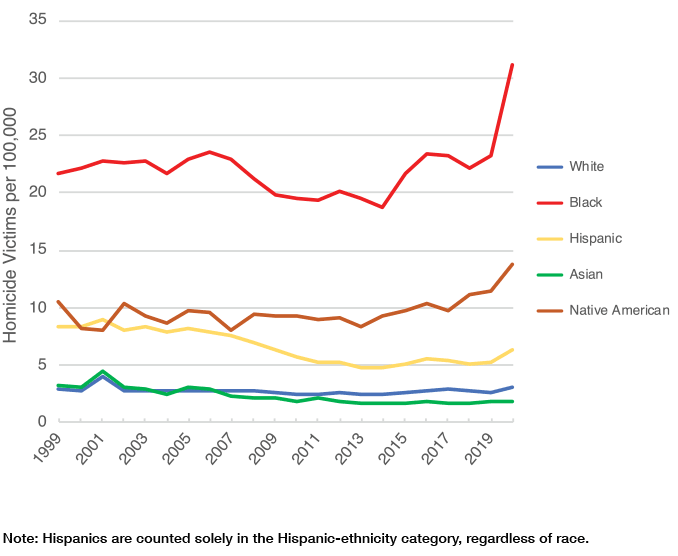
Related to figure 3 (copied here) we have this, which is excellent  QL material:

The racial and ethnic breakdown is perhaps most striking in this regard. Proportionally, homicide rates rose by about 34% for black Americans and about 19% percent for non-Hispanic whites: a notable, but not extreme, gap (Figure 3). But since the black homicide rate was already many times higher than the white one, this translated into 8 additional black deaths for every 100,000 population—an increase similar to the total homicide rate for the country as a whole—while the death rate for whites rose by only 0.5 per 100,000. (Recall that these numbers pertain to the homicide victims, not the killers, though American homicide is overwhelmingly intraracial.)

There is a lot to discuss in this article as well as ample quantitative literacy material. There is a discussion of methods and the CDC data they use is easy enough to locate.

* (This is the same note from Monday’s Post) Yes, MI has a clear political leaning but that doesn’t make their work incorrect. Their data and methods are sound here and this should be engaged not ignored. If someone thinks something is incorrect then let me know.


Is there a correlation between Homicide rate and voting?

The Manhattan Institute* has a lengthy report on the increasing homicide rate, Breaking Down the 2020 Homicide Spike by Christos A. Makridis and Robert VerBruggen (5/18/2022), with numerous interesting charts. From the report (figure 7 copied here):

Next, we explore the correlation between two geographic factors—population and GOP vote share—and the growth rate in the homicide rate per capita between 2019 and 2020. Each observation is a county whose size is determined by its population, giving larger counties greater weight. Counties with a higher share of GOP voters not only have lower homicide rates but also a lower growth in homicide rates between 2019 and 2020 (Figures 6 and 7).

There is a positive correlation between population in a county and the growth in the homicide rate, but the correlation between population and just the homicide rate is slightly negative (Figure 8). In this sense, even though there are slightly higher rates of homicide deaths per capita in smaller counties, some of those differences could be driven by spurious factors that are correlated with population.

There is a lot to discuss in this article as well as ample quantitative literacy material. There is a discussion of methods and the CDC data they use is easy enough to locate.

* Yes, MI has a clear political leaning but that doesn’t make their work incorrect. Their data and methods are sound here and this should be engaged not ignored. If someone thinks something is incorrect then let me know.


How big is the Dem/Rep perception gap?

More in Common did a perception gap study in 2018 and while it is a few years old it is worth reading. The graph copied here is the Democrats’ Perception Gap and the page has a similar one for Republicans. One interesting paragraph:

Education is intended to make us better informed about the world, so we’d expect that the more educated you become, the more you understand what other Americans think. In fact, the more educated a person is, the worse their Perception Gap – with one critical exception. This trend only holds true for Democrats, not Republicans. In other words, while Republicans’ misperceptions of Democrats do not improve with higher levels of education, Democrats’ understanding of Republicans actually gets worse with every additional degree they earn. This effect is so strong that Democrats without a high school diploma are three times more accurate than those with a postgraduate degree.

The page has 11 graphs and would make a great QL source for discussion in a class. One key question to ask is if the gap has gotten better or worse over the last few years.

How many billion dollar disasters in 2021?

The NOAA Billion-Dollar Weather and Climate Disasters page keeps track of these events.

During 2021, there were 20 separate billion-dollar weather and climate disaster events across the United States. The total cost from these events of 2021 was $145.0 billion and is the third most costly year on record, behind 2017 and 2005. The total costs for the last five years ($742.1 billion) is more than one-third of the disaster cost total of the last 42-years (1980-2021), which exceeds $2.155 trillion (inflation-adjusted to 2021 dollars). This reflects a 5-year cost average of nearly $148.4 billion/year — a new record — as shown above by the black line.

The chart copied here is interactive on their page and has lots of information. You can also select a state or region and get a similar chart. Data can be downloaded.

What are the trends in drug overdose deaths?

The Pew article Recent surge in U.S. drug overdose deaths has hit Black men the hardest by John Gramlich (1/19/2022) provides the graph copied here.

Nearly 92,000 Americans died of drug overdoses in 2020, marking a 30% increase from the year before, a 75% increase over five years and by far the highest annual total on record, according to the Centers for Disease Control and Prevention (CDC). Preliminary figures suggest that the 2021 death toll from overdoses may be even higher.

Overall

While overdose deaths in the U.S. were on the rise long before the outbreak of COVID-19 in March 2020, such fatalities have accelerated during the pandemic, the CDC has noted.

Nationwide, the monthly number of drug overdose deaths had never exceeded 6,500 before March 2020. Between March and December 2020, there were more than 7,100 such deaths each month, including nearly 9,400 in May 2020 alone.

There does not appear to be direct links to the data but there is plenty of quantitative info in the article.