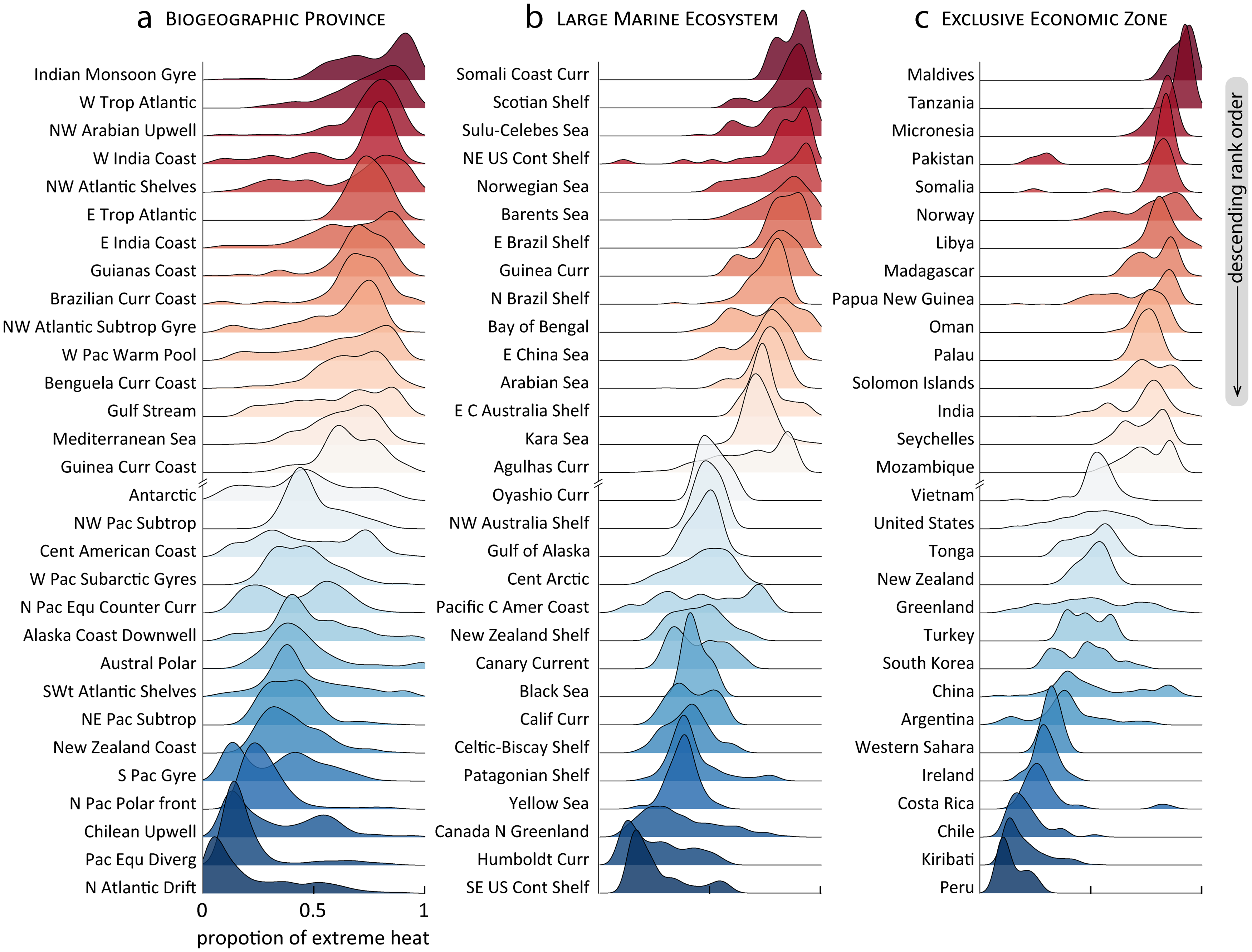
Tag Archives: climate change

What is the Global Climate Dashboard?

Climate.gov has put together a dashboard: Global Climate Dashboard – Tracking climate change and natural variability over time. The dashboard has graphs and information for greenhouse gases, arctic sea ice carbon dioxide, mountain glaciers, ocean heat, sea level, spring snow, incoming sunlight, and surface temperature under climate change (there are others under Natural Variability). This provides a nice one stop shopping for time series graphs for these variables.

For example, copied here is the graph for incoming sunlight:

Averaged over the complete solar cycle, there’s been minimal long-term change in the Sun’s overall brightness since the start of the Industrial Revolution. Records of sunspots show increased solar activity during the first 7 decades of the 20th century, likely tied to the peak of the last 100-year Gleissberg Cycle. Following that peak around 1960, solar activity declined. In fact, activity during the most recent solar cycle is among the lowest in a century. Meanwhile, the rate of global warming has accelerated over the past few decades.

Each variable is linked to a page with detailed information about the given variable. There don’t appear to be direct links to data but there are plenty of graphs.

How much has the Ocean warmed?

Climate.gov provides an updated on ocean heat in the Climate Change: Ocean Heat Content article by Luann Dahlman and Rebecca Lindsey (updated 10/12/2021):

Averaged over Earth’s surface, the 1993–2020 heat-gain rates were 0.37–0.41 Watts per square meter for depths from 0–700 meters (down to 0.4 miles), depending on which research group’s analysis you consult. Meanwhile, heat gain rates were 0.15–0.31 Watts per square meter for depths of 700–2,000 meters (0.4–1.2 miles). For depths between 2000–6000 meters (1.2–3.7 miles), the estimated increase was 0.06 Watts per square meter for the period from June 1992 to July 2011. According to the State of the Climate 2019 report, “Summing the three layers (despite their slightly different time periods as given above), the full-depth ocean heat gain rate ranges from 0.58 to 0.78 W m-2 applied to Earth’s entire surface.”

The article has helpful short summaries on how heat moves and measuring ocean heat. They link to Global Ocean Heat and Salt Content: Seasonal, Yearly, and Pentadal Fields for the data.

What is Thwaites?

Thwaites is an important glacier. In fact, it is so important it gets in own set of webpages. From The International Thwaites Glacier Collaboration (ITGC):

The NERC and NSF partnership, called the International Thwaites Glacier Collaboration (ITGC), covers research across Thwaites Glacier and its adjacent ocean region; the glacier flows into Pine Island Bay, part of Amundsen Sea. ITGC is the largest joint UK-US project undertaken on the southern continent in 70 years.

Over the past 30 years, the amount of ice flowing out of this 120-kilometer-wide region has nearly doubled. Overall the glacier is the size of the island of Britain, or the state of Florida, and it straddles some of the deepest bedrock in the southern continent.

From a CIRES article The Threat from Thwaites: The Retreat of Antarctica’s Riskiest Glacier (12/12/2021):

“Thwaites is the widest glacier in the world,” said Ted Scambos, a senior research scientist at the Cooperative Institute for Research in Environmental Sciences (CIRES). “It’s doubled its outflow speed within the last 30 years, and the glacier in its entirety holds enough water to raise sea level by over two feet. And it could lead to even more sea-level rise, up to 10 feet, if it draws the surrounding glaciers with it.”

The CIRES article has interesting information about the dynamics at play. The ITGC pages includes some education resources and a data page with links to data in various types but one is a csv file.


How hot was Nov 2021?

From NOAA’s Global Climate Report – November 2021:

The global average temperature over the land and ocean surfaces for November 2021 was 0.91°C (1.64°F) above the 20th century average of 12.9°C (55.2°F), the fourth highest for November since global temperature records began in 1880. The 10 warmest Novembers have occurred since 2004.

Some highlights:

The Northern Hemisphere had its second warmest November on record with a temperature departure of +1.24°C (+2.23°F). This was 0.06°C (0.11°F) shy of tying the record set in November of 2020.

Africa had its warmest November on record, with a temperature departure of +1.61°C (+2.90°F). This value surpassed the now second warmest November set in 2019 by 0.05°C (0.09°F). The Caribbean region had a near-record warm November (tied with 2016), behind the record set in 2015.

Time series data near the top of the page.

How hot was Oct 2021?

From NOAA’s Global Climate Report – October 2021:

The global surface temperature for October 2021 was 0.89°C (1.60°F) above the 20th century average of 14.0°C (57.2°F) — the fourth highest October temperature in the 142-year record. Only Octobers of 2015, 2018, and 2019 had a warmer October.

For the Northern Hemisphere:

The unusually warm temperatures across much of the Northern Hemisphere land resulted in the warmest October on record for the Northern Hemisphere land, surpassing the previous record set in 2019 by 0.11°C (0.20°F).

And for North America:

According to NCEI’s Regional Analysis, North America had its second warmest October on record with a temperature departure of +2.14°C (+3.85°F). This was only 0.03°C (0.05°F) shy of tying the record set in October 1963. According to Meteorological Service of Canada, Ontario (located in eastern Canada) had October temperatures that were 3.0–6.0°C (5.4°–10.8°F) above average. During October 7–15, several locations across Ontario had maximum temperatures above 20°C (68.0°F).

The time series data is at the top of the page.

Do you need a simple climate model app for the classroom?

UCAR (University Corporation for Atmospheric Research) has The Very Simple Climate Model page with a climate model where you set the emissions and then run the model until 2100. You get graphs of carbon emissions, CO2 concentration, and temperature. For example, the output in the graph here set emissions at about half the current level. Even then temperature goes up a degree F by 2100. The model can be run 1 year at a time with different emissions each year. There is a link to an activities page as well as some scenarios to explore.

How hot was Sept 2021?

From NOAA’s Global Climate Report – September 2021:

The global surface temperature for September 2021 was 0.90°C (1.62°F) above the 20th century average of 15.0°C (59.0°F) and was the fifth highest September temperature in the 142-year record. Only Septembers of 2015, 2016, 2019, and 2020 had a higher September temperature departure. The eight warmest Septembers have all occurred since 2014. September 2021 also marked the 45th consecutive September and the 441st consecutive month with temperatures, at least nominally, above the 20th-century average.

Some regional highlights:

The Southern Hemisphere’s September 2021 surface temperature departure of +0.70°C (+1.26°F) was the warmest September in the 142-year record, surpassing the previous record set in 2018 by 0.02°C (0.04°F).

According to NCEI’s continental analysis, Africa had its warmest September on record at 1.50°C (2.70°F) above average, surpassing the previous record set in 2017 by 0.07°C (0.13°F).

September 2021 was also South America’s warmest September on record at +1.94°C (+3.49°F). This value exceeded the previous record set in 2015 by 0.23°C (0.41°F).

Time series data is available near the top of the page.

What is the Groundswell report?

From the world bank:

This sequel to the Groundswell report includes projections and analysis of internal climate migration for three new regions: East Asia and the Pacific, North Africa, and Eastern Europe and Central Asia. Qualitative analyses of climate-related mobility in countries of the Mashreq and in Small Island Developing States (SIDS) are also provided. This new report builds on the scenario-based modeling approach of the previous Groundswell report from 2018, which covered Sub-Saharan Africa, South Asia, and Latin America. The two reports’ combined findings provide, for the first time, a global picture of the potential scale of internal climate migration across the six regions, allowing for a better understanding of how slow-onset climate change impacts, population dynamics, and development contexts shape mobility trends.

Key projection:

Over 216 million people could move within their countries by 2050 across six regions,

The report discusses their modeling (there is more than this) :

Both Groundswell reports use the same modeling approach, which allows for direct comparison of results and for aggregation to derive the global figure for internal climate migration. They take a scenario-based approach and implement a modified form of a gravity model to isolate the projected portion of future changes in spatial population distribution that can be attributed to slow-onset climate factors up to 2050. The Spotlight discusses the key innovations and scope of the modeling approach.

Quiz question for a class: Is the 216 million people a lot or a little?